
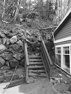
A Mercer Island neighborhood at S.E. 46th Street had a major landslide on Wednesday morning, Dec. 9, due to the duration and intensity of a multiday rain event in the region. The slide involved three neighboring properties and no injuries.
The city’s lead building official traveled to the affected site to assess the damage firsthand, and determined whether the buildings involved are still safe for occupancy.
The three properties were “red tagged” as unsafe, and residents had to find alternative accommodations. The city determined that there were ongoing risks posed by the possible expansion of the landslide, information supported by the city’s GIS mapping data.
“The city has very defined protocols for these events, and staff responded quickly to the situation,” said Ross Freeman, city communications and sustainability manager.
Two of the three property owners were unaware of the incident until informed by the city, according to a press release.
“The city provides emergency services and support in these situations, and ensured that all families had access to housing elsewhere,” the release stated.
All of the involved owners began to contact State-licensed geotechnical engineers for a detailed evaluation and suggested mitigation measures.
The Island typically sustains six to 15 landslides per year, which are often exacerbated by many consecutive days of heavy rain.
Learn more about landslides and forecasting at the city’s webpage, where you can also find a landslide factsheet and landslide hazard map.
See www.mercergov.org for more.