The Mercer Island rooftops, cars, backyard barbecues and garden chairs looked like plastic miniatures — detailed enough to recognize but small enough to pinch together with tweezers and modeling glue. But it was not until I saw an Island mother, child on hip, stroll out of the South-end QFC behind a packed shopping cart that I realized how close we actually were to the living miniatures below. Seven hundred and sixty feet, actually. That is how close we were.
A couple of weeks ago, I had the pleasure of flying alongside Island pilot Bob Brahm in his single-engine airplane. The excursion, a loop from the Renton Airport northeast to Lake Sammamish and back, was not only recreational. Brahm is one of many pilots utilizing a new GPS system that helps them descend into Renton Airport at a steeper angle. This allows planes to fly above obfuscating cloud cover and keep their noise level to a minimum while flying over the South end of Mercer Island, benefiting both the pilots and the residents below.
In November 2008, the Renton Airport — one of only a few airports providing aviation service for recreational flyers in the Seattle area — updated its air traffic network to accommodate the new GPS technology, which is called the Wide Area Augmentation System (WAAS). Although expensive, the technology is quickly being picked up by private fliers, according to airport manager Ryan Zulauf.
“Pilots seem to like it because the system allows them to fly on certain days where they can’t see the ground due to low cloud cover. Pilots can still descend through the cloud cover and land with a high degree of safety,” Zulauf said.
He added that the system also has perks for South end Mercer Island residents.
“It keeps the aircraft higher over Mercer Island, so the noise benefit is a byproduct to the weather feature,” Zulauf said. “Hopefully, as time goes on and people upgrade, we’ll see more of this equipment.”
Brahm, a former Alaska Airlines pilot, has already made the upgrade. The pilot purchased the WAAS system in 2000 and has been using it for most of his descents into Renton Airport ever since.
“The enhanced GPS gives you lateral guidance with improved accuracy, as well as vertical guidance with a constant rate of descent,” he explained. “A lot was taken into consideration when they developed this technology: How high can we keep pilots? How safely can we make the approach?”
In order to illustrate the difference between a WAAS landing and the basic GPS landing, Brahm decided that I would have to experience the descent myself as a passenger.
Takeoff
Like most recreational fliers who stow their planes at Renton Airport, Brahm keeps his Cessna 182 in one of the facility’s modest hangars. The plane, painted white and periwinkle blue, was light enough for Brahm to pull out of its hangar with a simple manual tow. Tiny yet comfortable enough for four, the cozy interior was just perfect for two up front and our Reporter photographer in the back. With the windows cracked open, we started the engine and taxied to the runway, eager to leave the 90-degree tarmac below.
As we positioned ourselves for takeoff, it became clear just how useful Mercer Island’s main artery — Island Crest Way — is to Renton aviators. Looking directly ahead, a gap in the Island’s forested skyline, signifying Island Crest Way, serves as the perfect horizon dial for takeoff. It is a visual extension of the runway, straight ahead into the distant blue sky.
After conducting a routine operational safety check and waiting for the air traffic controller’s go-ahead, Brahm revved the engine and we were off. Into the air, up and over the South end of Lake Washington and down the spine of Mercer Island.
Traveling through air space, like on land, requires a detailed traffic system. Because Renton Airport is located so close to Sea-Tac International Airport, its pilots have a number of Federal Aviation Association (FAA) restrictions to abide by. For instance, planes can only depart at a flying altitude of 2,000 feet or less on what is called the “East Channel loop.”
“We have to deal with both Boeing and Sea-Tac. You can’t take off from Renton to the west because you’re in Boeing’s airspace. So we have to head east over Mercer Island, while staying below 2,000 feet,” Brahm explained, adding that he must keep in contact with air traffic towers along the way.
And so eastward we went, turning away from Mercer Island’s racing I-90 corridor and over the mega-mansions that line Bellevue’s Lake Washington shore. By the time Brahm flew within range of the HAVHO navigational waypoint, located just north of Lake Sammamish, we were soaring above the beautiful Issaquah foothills at approximately 2,000 feet. And then we looped back, preparing to simulate the basic GPS system descent. Brahm briefly explained the technology.
“The basic GPS system gives you lateral guidance only. It relies on satellites. The instruments show that you’re descending at about a three-degree angle, compared to a four-degree angle with WAAS,” he said.
We dropped to 1,600 feet over Medina and gradually down to 800 feet as we approached the Island’s northern tip. And that is when I first noticed the ubiquitous Island cyclists, looping their way around North-Mercer Way — so close that I could see the sun glint off their white plastic helmets.
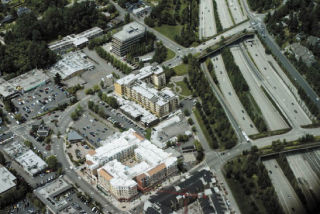
“Now we’re going to drop to our minimum flying altitude, 760 feet,” our pilot said, just as we passed over Mercer Island High School. I counted three joggers, looping their way around the track. Students milled outside the MIHS commons, most likely enjoying a break between class. By the time we passed over the South-end shopping center, I could recognize parking signs and mailboxes. We were that close.
‘Fabric’ of Seattle
Although many South-end residents complain about the noise that private planes make during their Renton Airport descent, Brahm considers it an essential — not to mention enjoyable — part of the Lake Washington landscape.
“I lived on the South end under the approach path for years, and I loved the planes above. The noise aspect doesn’t stand up to critical thinking. Renton Airport is a significant economic plus for the area. Boeing is part of the fabric of Seattle,” he said.
Indeed, Renton Airport ranks among the top six airports in the state of Washington in terms of aircraft landings and takeoffs. The Boeing Commercial Airplane Company, located adjacent to the airport, manufactures Boeing 737 aircraft and uses the airport for its initial flights. The facility serves air charter, air taxi, corporate, business and recreational flyers. It is also an FAA-designated “reliever” airport, diverting general aviation aircraft traffic from Sea-Tac International Airport. According to Brahm, the airport facilitates 100,000 operations a year.
“Where would all this business go without Renton Airport?” he asked rhetorically. “There are too many naysayers out there. I mean, when you buy a house and can see the airport across the lake, what does that tell you?”
Although the number of complaints from Island residents has dropped dramatically in the past year — from 50 complaints between December 2007 and June 2008 to six complaints between December 2008 and this month — Zulauf said that there is no evidence that this drop directly correlates with the new WAAS system. Other factors, such as the economy, could have also had an effect.
“When people have less money, they’re less likely to fly. There’s been a belt tightening with all of our tenants,” he said.
Yet the airport manager asserted that, if more pilots adopt the new GPS system, fewer Lake Washington residents will complain about overhead noise. Based on my experience with the WAAS technology, I had to agree.
On our second experimental descent over the Island, using the WAAS system, we hovered so far above Mercer Island that I could barely distinguish cars parked in a lot below. The rooftops looked like square Legos, and the trees meshed as textured green space. This difference in altitude was matched by the silent purr of the engine as we glided 2,000 feet above the earth.
“The new system keeps you higher for longer and you descend at a steeper, 4.2-degree slope. The noise is less because as you’re descending, the plane’s power is reduced,” the Islander explained. “We’re almost as quiet as we could be flying a plane right now.”
And so we silently hovered above the South end, dropped over the calm waves of Lake Washington and smoothly, with the Renton air-traffic controller assuring us a clear runway, let our wheels touch the sweltering tarmac once again. We taxied back to Brahm’s hangar, climbed out of the small plane, and thanked him for a majestic ride — purely for the sake of empirical journalism, of course.