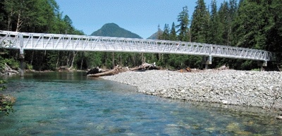
From afar, the new Ice Caves Trail Bridge shines as white as the glacial snow just a mile up the trail. Up close, the 224-foot aluminum span gleams silver, its durable aesthetic built to weather any flooding that the South Fork Stillaguamish River can roil up.
Just a hop, skip and a leap from Mercer Island (74 miles northeast), the second-most popular trail in the Mt. Baker-Snoqualmie National Forest has now reopened to hikers.
“In November 2006, after 40-50 inches of rain, the river took the wooden bridge that was there and just whipped it around to an L-shape,” says Don Temple, volunteer for the Darrington Ranger District. Ever since, Big Four Mountain’s ice caves have remained inaccessible to most. “The bridge being out didn’t stop everyone,” Temple adds. “Some still waded across.”
Such derring-do is no longer necessary, since the Western Federal Lands Highway Division of the Federal Highway Administration stepped forward with $425,000 in ERFO (Emergency Relief — Federally Owned) funds to install the impressive new Ice Caves Trail Bridge.
The official ribbon-cutting dedication was held on Friday, July 10.
Behind the U.S. Forest Service podium, Big Four Mountain and Hall Peak formed a cookie-cutter backdrop against a cloudless blue sky. Participants included representatives of the Darrington Ranger District, the Snohomish County Council, the Federal Highway Administration, Northwest-area U.S. congressional offices, and the mayor of Granite Falls.
Unofficially, the bridge has been open since June 27, after a five-week, intensive construction project that involved airlifting bridge sections in by helicopter. About 1,000 visitors have flocked to the Big Four area every weekend since. While the manmade span is now in place, nature’s ice caves have yet to make their debut.
“There’s still a lot of snow up there. You need a combination of warmer water, warmer air to really get the caves forming,” says Peter Forbes, district ranger for the Darrington Ranger District.
No matter. The Ice Caves Trail is always worth the trip. But to see the caves, August through October is best. In just one mile, the trail ascends gently along a beaver-created wetland through shady Silver Fir forest slopes to stunning ice fields and craggy views of the 6,153-foot Big Four Mountain. Numerous sturdy wooden sidewalks span the sometimes muddy portions of the hike. By next year, after further trail repairs, the mile to the ice caves should be accessible to the disabled.
It is dangerous to actually enter the caves, since avalanches and rockfall can occur at any time. Therefore, spectators are strongly encouraged to view them (and take photos — don’t forget your camera!) from a lookout point close by. The lovely subalpine meadow surrounding the lookout don’t forget your camera!) from a lookout point close by. The lovely subalpine meadow surrounding the lookout point abounds with wildflowers, and snow-cooled breezes bring delicious relief from the heat of the hike. point abounds with wildflowers, and snow-cooled breezes bring delicious relief from the heat of the hike.
Even the drive up the Mountain Loop Highway provides breathtaking scenery and views. Reopened in its entirety in 2008, the well-maintained road meanders alongside the Stillaguamish River, past National Forest campgrounds and numerous hiking trailheads. (Gold Basin Campground is the one with showers, but there are also Verlot and Turlo Campgrounds on the same stretch of highway.)
Must brings: Sunscreen. Don’t let the shady forest at the beginning of the trail fool you. The sun-on-snow combination at the caves will sizzle skin in a hurry. And lastly, a Recreation Pass (Northwest Forest Pass). This annual $30 pass is required for all vehicles parked at National Forest trailheads.
IF YOU GO
Directions: Take I-90 East to I-405 North. Merge onto I-5 North to Everett, exiting at U.S. Highway 2 (Exit 194). Almost immediately, merge left onto State Route 204 East to Lake Stevens. In just over two miles, turn onto State Route 9, heading north. Turn right onto State Route 92 to Granite Falls. Where SR-92 ends in Granite Falls, turn left (toward Darrington) on the Mountain Loop Highway. Big Four Picnic Area and Ice Caves Trailhead are about 25 miles east of Granite Falls, on the righthand side of the road.
Verlot Public Services (for maps and information on the drive up)
33515 Mtn. Loop Highway
Granite Falls, Wash., 98252
Phone Number: (360) 691-7791
Darrington Ranger District: www.fs.fed.us/r6/mbs/about/drd.shtml
Trail conditions: www.fs.fed.us/r6/mbs/conditions/index
Recreation Passes required to park in National Forest Service areas: www.fs.fed.us/r6/passespermits/
Dogs permitted on leash.