
The draft Shoreline Management Plan (SMP) is nearing an important milestone as it works through another phase of review by the Mercer Island City Council. The Council is set to vote to approve a draft of the plan on Aug. 1. If approved, it is then sent off for a formal review by the Washington state Department of Ecology (DOE) and other regional and federal agencies.
It is a big deal. There is much at stake.
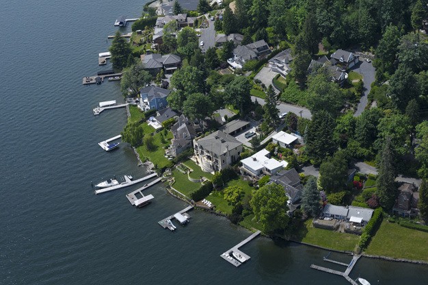
The SMP, along with city building codes, the city’s comprehensive plan and other state and national regulation statutes, governs the use of the 14-plus miles of shoreline around the Island. More than 900 homes are situated on the shoreline, most with docks, bulkheads and other structures.
The shoreline area is 357 acres in size and encompasses more than 77,000 linear feet of shoreline, the equivalent of 14.7 miles. Of the 972 lots along the shore, all but 27 are designated for urban residential use. Of the residential lots, 57 are vacant.
Since 2000, 286 permits were granted for work within shoreline areas on the Island. Permits were issued for building or replacing docks, bulkheads or other structures. Permit activity has been steady since 2000, with about 4 percent or 36 issued per year. Of those, the majority were for dock or pier modifications or replacement, followed by bulkhead modifications, or for building construction. Out of the total, just 86 significant development permits were issued.
The present SMP was first approved in 1971 and updated in 1974. The new plan, required by state law, has been in progress since early 2009. The city has made the plan available for comments and input from residents since that time.
The city has forwarded the plan at various point to the State Department of Ecology (DOE) and groups such as the nonprofit Futurewise. They have offered written comments and criticisms of the plan along the way.
Barbara Nightingale is the regional shoreline planner with the DOE for Mercer Island’s plan. She and the staff at DOE want more analysis from the city on how they plan to deal with future shoreline changes that may harm the Puget Sound Chinook that migrate through Lake Washington from the Cedar River watershed to Puget Sound. The particular species of salmon in the lake linger near shorelines for protection from predators. In order for them to thrive, they need to be able to see potential predators.
The plan put forth by the city has not adequately taken the threatened species status of the salmon into account, she explained.
Puget Sound chinook salmon are protected under the federal Endangered Species act. Chinook populations in Puget Sound have declined significantly since the 1960s.
Studies have also positively linked the survival of these salmon and Puget Sound killer whales, also protected under the ESA. Chinook are the principal food source for the whales.
Differences that remain between the city’s plan and DOE and Futurewise are found in the need to further restore native vegetation along the shoreline and how to mitigate shading of the water, caused by docks or boathouses that shade the water.
Based on the concept of “no net loss of ecological function” beginning from the present, any new standards will only come into play if structures along the shoreline are replaced or rebuilt. The majority of homeowners along the water will not have to make significant changes based on the new plan. Stricter standards will primarily apply to new development on the shoreline.
DOE staff maintains that dock walkways should be no wider than 4 feet without measures that will offset the increase in shading. Many docks along Mercer Island shores are up to 8 feet wide. DOE maintains that if the city wants to allow that width when permitting a new structure, they need to present a means to offset the impact of the larger structure, such as increasing native vegetation nearby. DOE and others say that if docks or walkways are replaced, they should be done so with grated decking, which allows light to pass through to the water.
From the DOE’s point of view, “both the lack of adequate science presented and a plan to mitigate loss of function, weaken the existing plan,” Nightingale explained. She said that in order for the DOE to sign off on the plan, the city must provide more.
However, Nightingale said that a trip around the Island by boat just a few weeks ago — her first — was “a real eye-opener” for her.
She was impressed by the homes along the shore in terms of how far they are set back, the generous amount of space between neighboring structures and the already extensive use of natural vegetation. She also praises the work of the city’s development staff.
“They pay attention,” she said. “They have worked hard.”
City of Mercer Island Development Director Tim Stewart said that at this point, it is up to the City Council to decide what kinds of policies it will pursue in advancing the plan to the next stage. Those policies or directions include what standards the Council would propose for the sizing and materials of docks. When that is established and the Council votes to approve the draft plan, the plan will be forwarded to DOE for more review.
