
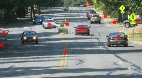
Island Crest Way will remain four lanes from Merrimount Drive to Southeast 40th Street as the city of Mercer Island continues a 10-week project to repave and improve drainage on the road.
The project, which started July 18 and is planned for completion by the end of September, does not involve the controversial three lane reconfiguration implemented in the 4300-5300 blocks of Island Crest Way in 2012.
But several data requests from the Washington State Department of Transportation (WSDOT) for crash data on Island Crest Way from 2001 to 2016 indicate that the lane reconfiguration has reduced accidents on the Island’s main thoroughfare in those blocks. The data shows a 61 percent reduction in non-injury collisions and 75 percent fewer injury accidents.
The idea for the road diet came from a concern about the safety of the intersection at Merrimount Drive, known as the “worst intersection on the Island.” There was about one accident per month on Island Crest Way in that vicinity between Jan. 1, 2001 to Nov. 30, 2007. The four-lane road design resulted in narrow shoulders and dangerous crossing situations for pedestrians.
City staff presented options to the council, from an expensive stoplight to a lane reconfiguration that would change Island Crest Way from four lanes to three, one lane going each direction with a center left-turn lane, in the mid point of the Island.
The plan, which would become known as the “road diet,” spurred a contentious debate in the community, with many arguing that their quality of life and property values would be negatively affected. The council approved the lane reconfiguration and a $650,000 repaving project.
But in June 2010, a 4-3 majority suddenly defunded the project while adopting the city’s 2011-2016 Transportation Improvement Program (TIP). Current Councilmembers Bruce Bassett and Dan Grausz, who served on the council at the time, were in the minority, along with then-Mayor Jim Pearman.
Also in June 2010, a freshman at Mercer Island High School was hit by a car while crossing at the 4200 block of Island Crest Way on his way to school.
The accident showed one of the dangerous situations caused by a four-lane configuration: the crossing teen was hit by the driver in the second lane, who didn’t see him because of the stopped car in the first lane.
Other issues occur when drivers don’t stop in time behind left turning vehicles and rear end them, or do stop but are rear ended themselves. Cars are also broad swiped while attempting to turn across multiple lanes and side swiped while other cars around them change lanes.
The road became slightly safer, as incremental improvements were made at the Merrimount intersection, Southeast 44th Street was changed to a one-way road and stoplights were installed at Southeast 47th Street and Southeast 42nd Street. There were 53 accidents between Oct. 1, 2007 to Aug. 31, 2012, for an average of 10.77 per year.
There was citizen outreach and a task force formed in 2008. “Citizens for a Better Island Crest Way Corridor” created a website in 2009. Champions of the road diet, including Bassett, who is now the mayor of Mercer Island, were able to push it through in 2012. Bassett said he toured other road diets in the area and found them to be a “much more pleasant experience.”
“It was easy, having observed that, to see what our outcome could be like,” he said.
There were 19 accidents between Nov. 1, 2012 to Aug. 11, 2016, for an average of 4.82 per year (down from 12.3 in 2001-2007, before the Merrimount experiment).
Speeds and traffic volumes have also gone down slightly, meaning the road is safer, but not more congested. In February 2008, the average northbound speed was 41.4 miles per hour and 18,318 cars were using the road on an average weekday at the 4700-4800 blocks. In October 2014, speeds settled around 37.6 miles per hour with a volume of 15,833 cars, according to city data compiled at the closeout of a resurfacing project.
Bassett said that on a four-lane road, aggressive drivers set the top speeds, while speed limit observers tend to dictate top speeds on a three-lane road.
The 2010 incident wasn’t the first car-versus-pedestrian collision at the crosswalk near Southeast 42nd Street. In June 2005, a car struck Steve Ybarra as he used the same crosswalk. Ybarra sued the city for negligence to improve pedestrian safety in the area, and won $22,000.
During the 2007 trial, city engineer Patrick Yamashita testified the city had changed the crosswalk design from two parallel strips to “piano key” stripping, used reflective paint, installed reflectors on both sides and changed the color of nearby warning signs from yellow to fluorescent green to improve pedestrian safety prior to the accident.
The road was still unsafe, and lane reconfiguration supporters thought the solution was a traffic calming plan throughout the Island Crest Way corridor. Other citizens weren’t sure if a road diet was the answer. There were multiple points of opposition: some thought the problem could be solved with a traffic signal, and others worried that the plan would divert vehiccles onto neighborhood streets, cause traffic delays and favor bikes over cars.
Having a wider shoulder and bigger buffer between the sidewalk and passing cars was a decision made for safety reasons, Bassett said, and not out of preference for cyclists. The main north-south bike route on the Island does not run on Island Crest Way, but on side streets like 90th Avenue Southeast.
City staff and council members in favor of the plan presented studies on the benefits of lane reconfigurations. A Seattle study of road diets found an average accident reduction of 25 percent. A 1999 Walkable Communities, Inc. report said that the “ideal roadway patient is often a four-lane road carrying 12,000-18,000 auto trips per day.” The record for roadway conversion with highest traffic counts is Lake Washington Boulevard in Kirkland, Wash., with 30,000 vehicles (ADT).
Other roads in the area have been coverted, including Northeast 85th Street in Redmond, Eastlake Avenue East in Seattle and Ambaum Way in Burien.
The report also noted that with one lane conversion in Pennsylvania, “dangerous maneuvers and crashes dropped to nearly zero [and] overall trip times were unaffected.” Two-way left-turn lanes “add as much as 30 percent to efficiency of movement, and they often cut the number of crashes in half,” it added.
“None of us wants to spend time slowed down,” Bassett said. “But the data shows that [the road diet] is achieving exactly what it was supposed to achieve.”
Bassett said that while doorbelling during his re-election campaign last year, he heard from a few Islanders that the road diet was great, or that it’s “the dumbest thing” the council ever did.
“From the rest of the world, it’s silence,” he said. “That’s an indication of a win.”
More information and updates about the current Island Crest Way project are posted on the project webpage at www.mercergov.org/ICWresurfacing2016.
